The Evolution of Roundhouse Park - Part 2 of 7
 Click on the picture for a closer look!
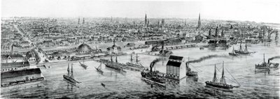
The above shows Toronto Harbour in 1873. Railway tracks and related facilities fill most of the newly claimed land between Front Street and Lake Ontario. John Street intersects Front in the middle of this view. Roundhouse Park would be located just above the two masts of the sailing ship at the bottom. At least ten church steeples dominate the horizon, the tallest of which is St. James Cathedral at King and Church Streets. Just to the right of the steeple in the middle ground close to the harbour can be seen the three towers of Toronto's second Union Station, opened in 1873. The bridge over the tracks on the left of this view carries Brock Street as Spadina Avenue was then known.
The large structure to the right of the bridge is the fully enclosed Grand Trunk Railway roundhouse, later replaced by the Canadian National Spadina roundhouse and later still by Skydome, which was obviously not the first domed structure to occupy this site. The smallish building with the chimney located centre view between the grain elevator and the train is Toronto's first water pumping station. This was built to combat the frequent cholera epidemics that plagued the populace when they drank water right out of the badly polluted Lake Ontario. The station pumped water as far away as the Rosehill Reservoir, located five miles to the northeast, just south of St. Clair Avenue. The Grand Trunk Railway grain elevator is the most prominent feature on the waterfront. At the time, Toronto was the largest exporter of grain to the U.S. eastern seaboard, although most of it originated in the American Midwest and was shipped by rail from Collingwood to Toronto to avoid a lengthy voyage through the Great Lakes. There was another huge grain elevator operated by the Northern Railway further to the west, the top of which probably provided the perspective used by the artist to create this image.
Click here to read the next in this series of excerpts from Derek's article - The Evolution of Roundhouse Park.
Story by Derek Boles, TRHA Historian; Image from the collection of Derek Boles.


<< Home